In this guideJump to a section
If your phone says “wintry mix,” the word alone does not tell you whether your road will be wet, covered in pellets, or glazed with ice. The key difference is what reaches the ground: sleet arrives as small ice pellets; freezing rain arrives as liquid drops that freeze when they touch a surface at or below freezing. Both can make travel hazardous.
This page explains the precipitation terms and gives you a short way to turn a local forecast into a travel and home-check decision. It does not replace a live forecast, road report, or local emergency instruction. For alert meanings and the full-message checklist, use the Winter Storm Watch vs. Warning guide; for storm-wide preparation, see the Winter Storm Preparedness Guide.
Freezing rain vs. sleet
Most winter precipitation begins as snow high in the cloud. A layer of warmer air can melt some or all of it as it falls. What happens in the colder air near the ground separates sleet from freezing rain. The National Weather Service describes sleet as drops that refreeze into pellets before landing, while freezing rain stays liquid until it hits a surface cold enough to freeze it. NWS explanation
| What you notice | Sleet | Freezing rain |
|---|---|---|
| What reaches the ground | Small ice pellets | Liquid drops that freeze on contact |
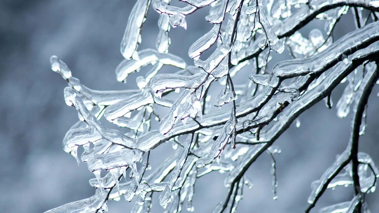
| Common surface clue | Pellets may bounce or collect like snow | A smooth, clear glaze may coat pavement, steps, branches, vehicles, and lines |
| Why it matters | Pellets and packed or mixed precipitation can make roads slick | Ice can bond to exposed surfaces; even a light glaze can make driving dangerous |
| What the label cannot tell you | Whether the route is passable or when conditions improve | How much ice a particular tree, wire, walkway, or road has accumulated |
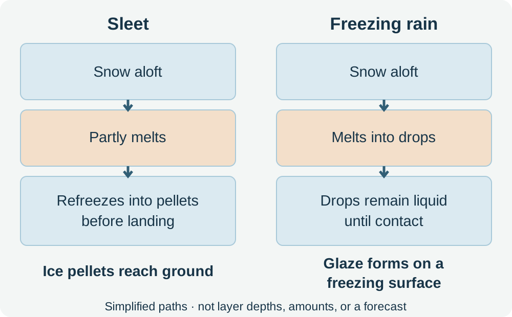
Simplified formation paths based on the NWS explanation. Layer depths and temperatures vary; this is not a forecast.
The table describes precipitation, not a safety ranking. Sleet can accumulate and become slippery; freezing rain can glaze surfaces that look merely wet. A mix can change over time or differ across nearby areas. Treat either forecast as a reason to check the stated impacts and current local instructions, not as permission to travel. NWS winter hazard definitions
Why the surface can be icy when the air is above freezing
An air-temperature forecast does not measure every road surface. The National Weather Service notes that ice can form when air or road temperatures fall below freezing, and that roads may be slick even when they look wet. Bridges are exposed to cold air above and below, so conditions can differ across a route. Do not use one thermometer reading to clear a route or doorstep; use local forecasts and road authority reports. NWS winter driving guidance
What to read in the local forecast
Look beyond “sleet,” “freezing rain,” or “wintry mix.” Find the detailed forecast or alert for your location and record:
- the expected start and end window, including when a change in precipitation type is possible;
- the precipitation types and any expected accumulation or range, with its time period;
- the temperatures and wind or visibility concerns that could affect your route;
- the impact statement, such as slippery roads, difficult travel, tree damage, or possible power interruptions;
- local road closures, travel restrictions, school or transit notices, and emergency instructions.
Forecasts can be revised as the event approaches and as observations come in. A forecast category or estimated amount is not a measurement at your home, and it does not describe every street. Check for updates before a trip and use official local road and emergency sources for current conditions. The National Weather Service notes that winter alert criteria vary by issuing office; a headline is only one part of the message. NWS winter alerts
Make a household travel decision
First ask whether the trip can wait. Follow road closures and local travel instructions. For a Winter Storm Warning, the NWS says travel may become difficult or impossible in some situations and advises delaying plans until conditions improve. No vehicle feature can establish that a road is safe. NWS winter alert guidance
For a trip that is essential and not restricted, compare the trip window with the forecast window and current road reports. Consider whether everyone traveling can manage a delay, low visibility, a breakdown, or arriving later than planned. If the information is changing or the route report is missing, postponing is a reasonable choice. Do not drive out to inspect a road or bridge.
At home, check only what can be seen safely from the ground: entrances, steps, the usual path to a vehicle, and whether branches or lines appear affected. Do not touch downed or sagging wires, approach damaged trees, climb to remove ice, or treat an unmeasured surface as safe. Follow utility and emergency-service instructions for hazards. The winterizing and frozen-pipe guide covers property-specific pipe protection; it does not prescribe a response to ice on roofs, trees, roads, or power lines.
Forecast-to-action worksheet
Use this record for one location and one decision. Copy only public forecast details; keep household names, medical needs, routes, and contact information on a private plan.
| Record | Fill in |
|---|---|
| Location and forecast source | Place or forecast zone: _ Source / issuing office: _ |
| Checked at | Local date and time: _ Next check time: _ |
| Forecast wording | Sleet / freezing rain / mix / other: _ Possible change: _ |
| Timing | Expected start: _ End or improvement window: _ |
| Amount and period | Forecast range and units: _ Period it covers: _ |
| Expected impacts | Road, visibility, wind, branches, power, or other impacts named: ___ |
| Official instructions | Road closure / travel advice / emergency action: ___ |
| Household decision | Postpone / use another plan / go only if still permitted: ___ |
| Trigger to check again | New alert, road update, or forecast time: ___ |
This worksheet organizes the forecast; it does not calculate ice loading, prove road conditions, or set a universal accumulation threshold. Update it when the issuing office or road authority changes its information. If the trip is postponed, choose the next safe time from current official updates rather than a fixed number of hours.
Keep the forecast worksheet with your winter plan, and revisit it when the local office updates its timing or impacts. The winter alert guide explains the watch, warning, or advisory that accompanies those details.