El Niño 2026–27: What Homeowners Should Prepare for Before Winter
Turn the dated El Niño forecast into three winter priorities for your household, using historical lessons, regional outlooks, and the gaps that matter at home.
In this guideJump to a section
- What NOAA and WMO say as of September 29, 2026
- What earlier strong events can teach a household
- Regional tendencies are a starting point
- Household failure points worth checking first
- California households: follow the property path
- From a seasonal outlook to a local decision
- Choose three winter priorities
- Household Winter Priority Card
- Common questions
A winter forecast is useful when it changes something you can do before the rain starts. Look for the gap that would make an ordinary disruption harder: a missed alert, a leaking entrance, a phone you cannot charge, or a care plan that depends on uninterrupted power. The goal is three assigned actions, not a prediction of the worst storm.
An active warning changes the task
This is advance planning. If a warning or evacuation order applies now, read the complete local NWS message and follow emergency officials. A flood or flash-flood warning calls for action. Do not walk, swim, or drive through floodwater; follow NWS flood safety guidance.
The rainy-home hero is an AI-generated illustration, not a photograph of a documented storm.
What NOAA and WMO say as of September 29, 2026
NOAA’s September 10 ENSO discussion reports an El Niño Advisory and strengthening conditions. It puts the chance of a very strong event during Northern Hemisphere fall and winter 2026–27 above 90%. Separately, it gives a 75% chance that October–December meets its historic-strength threshold: a three-month Relative Oceanic Niño Index, or RONI, of at least +2.5°C, compared with events since 1950. Those are probabilities about the Pacific climate event, not your chance of a flooded home.
The WMO August 2026 edition, published September 3, also expects strengthening and gives nearly certain persistence through December 2026–February 2027. WMO expressly cautions that strength does not translate directly into the size of impacts in a region. A persistence forecast and a strength forecast answer different questions.
Use those dated assessments to make time for preparation. For rainfall and temperature categories, consult CPC’s seasonal outlooks. For the next storm, consult your local NWS forecast and emergency alerts. NOAA schedules its next ENSO discussion for October 8, 2026; recheck the source rather than treating this September snapshot as current all winter.
What earlier strong events can teach a household
Strong El Niño winters have produced different outcomes. The table separates observed history from the present forecast; the last column is our editorial lesson, not a finding that these actions would have prevented past damage.
| Event | Evidence and geography | Household lesson — editorial synthesis |
|---|---|---|
| 1982–83 — observed | NOAA’s historical California research identifies a very wet November–April season. That says nothing about the same outcome in every U.S. region. | Take recurring rain-entry or drainage problems seriously before winter; arrange repairs with the responsible owner or professional. |
| 1997–98 — observed | The same research identifies another very wet California season. Its rainfall outcome is a historical observation, not a template for this winter. | Keep alerts, essential documents, and a plan for interrupted services usable when repeated storms make ordinary errands difficult. |
| 2015–16 — observed | Research published in 2018 found normal-to-below-average California precipitation in late winter, despite wetter expectations. This is a narrower period than the earlier November–April comparison. | A strong event is not a reason to expect identical rainfall, snow, or local disruption. Maintain ordinary winter readiness even if the forecast changes. |
| 2026–27 — forecast | September NOAA and WMO outlooks expect a strong continuing event. Seasonal and property outcomes are still ahead. | Choose actions useful across several outcomes; update the plan when local forecasts become specific. |
The historical evidence comes from NOAA PSL’s December 2015 research summary and Jong and colleagues’ 2018 analysis. The first source’s predictions for 2015–16 must not be mistaken for results. The later paper explores Pacific warming patterns, model sensitivity, and atmospheric variability; it does not settle on one explanation for the different rainfall outcome.
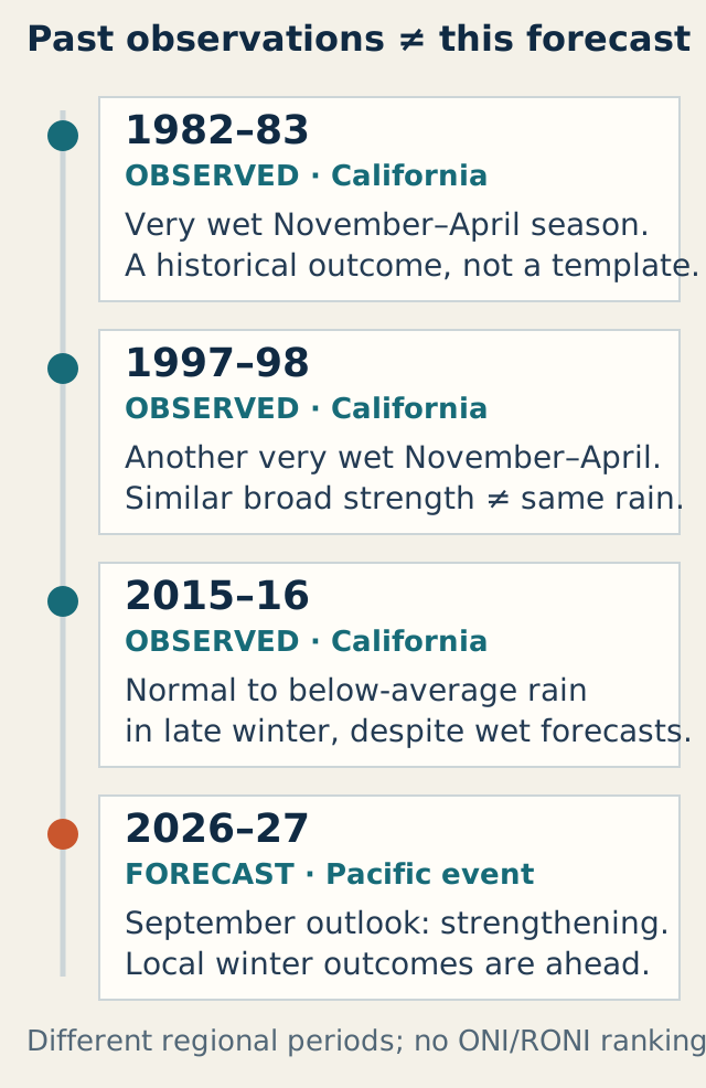
Different periods and regional outcomes, not a ranking of event strength. Sources:
NOAA historical summary
,
2018 California research
, and
September 2026 CPC discussion
. The table above contains the equivalent information.
We have deliberately avoided putting historical ONI values beside the current RONI forecast to declare a winner. They are different measurements, and a strength ranking would not establish a local damage ranking anyway.
Regional tendencies are a starting point
El Niño couples unusually warm water in the central and eastern tropical Pacific with atmospheric changes. The usual winter pattern can favor a stronger southern U.S. storm track and milder conditions farther north. NOAA’s North American winter explanation, last modified in 2017, describes that broad tendency; the current seasonal outlook is the better source for this event.
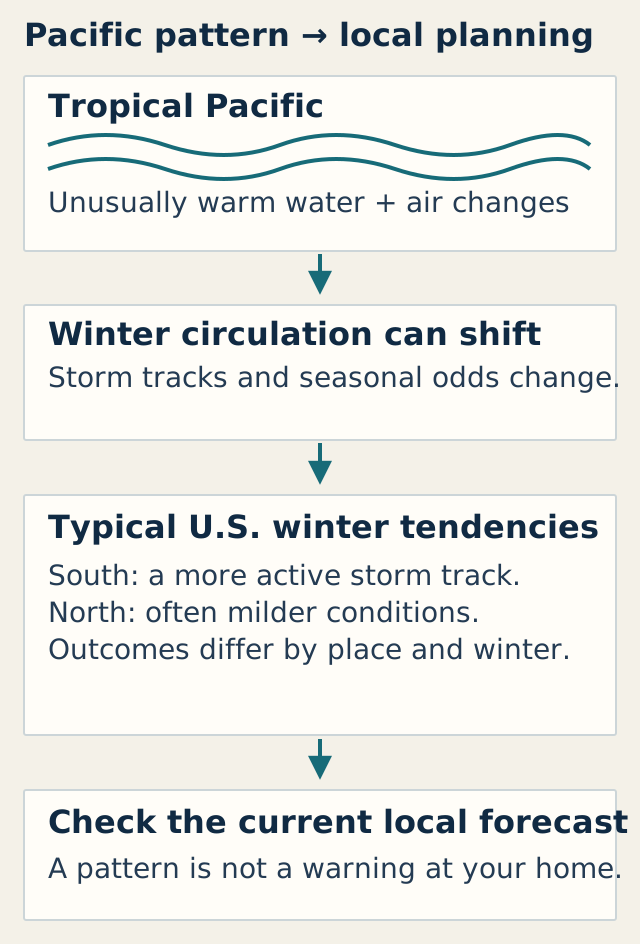
A conceptual pathway, not a warning map. Based on
CPC’s winter-pattern explanation
and the
September 17 seasonal discussion
. The regional table below describes the planning implications in text.
| Region to locate on the current outlook | September 17 forecast context | Preparation question |
|---|---|---|
| Southern California, much of the Southwest and Plains, Mississippi and Tennessee valleys, Southeast, and Mid-Atlantic | The October–December outlook favors above-normal precipitation in these broad areas. Exact boundaries vary. | Have past rain events exposed an entry, drainage, transport, or outage problem you can address now? |
| Interior Northwest and parts of the Great Lakes | The October–December outlook tilts toward below-normal precipitation in some areas. | Is the ordinary cold-weather outage plan ready even if the seasonal total is lower? |
| Many northern and western areas | Later winter outlooks favor warmer-than-normal seasonal averages in broad areas. | Would one cold spell still interrupt heat, pipes, travel, or care? A warmer average does not remove that question. |
| Alaska, Hawaii, and places outside these broad descriptions | Conditions and forecast products differ; a contiguous-U.S. summary is insufficient. | Which official regional outlook and local office cover the household’s location? |
These are summaries of CPC’s September 17 discussion, not fixed boundaries for the whole winter. Check the map for the exact three-month period. “Above normal” describes a seasonal total category; it does not mean rain on every day, a certain percentage more rainfall, or a guaranteed flood. “Equal chances” gives no favored category, rather than promising an uneventful season.
Household failure points worth checking first
The most useful priority often predates El Niño. Think of the last time bad weather changed your day, then choose the unresolved dependency.
| Possible gap | Useful next action | Limit or responsible contact |
|---|---|---|
| Alerts arrive on only one phone | Confirm official local alert enrollment and a second way to receive information. Agree who passes on a message. | Use local emergency-management instructions; a charged phone alone does not guarantee service. |
| Heat, a building pump, or essential equipment depends on electricity | List what stops when power fails and identify an alternative location or backup plan. | Consult the utility, landlord, clinician, device supplier, or qualified electrician as appropriate. |
| A known leak, ponding point, or loose outdoor item | Record the issue from a safe place and assign the maintenance request. | A resident’s observation is not a roof, drainage, structural, or slope assessment. |
| Supplies or documents are hard to reach | Put the items needed for departure or a short interruption in an accessible place. | Account for mobility and care needs; follow official evacuation instructions when issued. |
The CDC outage guidance explains why temperature, food, water, and powered needs deserve attention. For a detailed cold-weather sequence, use the Winter Power Outage Guide.
Backup power needs a safety plan
Never run a portable generator inside a home or garage, even with doors open. CDC’s January 2026 guidance says to operate it outdoors more than 20 feet from windows, doors, and vents, with working battery or battery-backup carbon-monoxide alarms. Distance alone does not approve a site or connection: the exact manual, exhaust direction, weather, neighboring openings, code, and qualified electrical guidance matter. The Generator Safety Guide covers that separate decision.
Hypothetical planning example: a renter without backup power
A renter cannot schedule roof repairs and has no existing power backup. Their first three priorities might be reporting a recurring entrance leak to the property manager, checking local alert delivery, and arranging a reachable place to stay if the unit loses safe heat. A written maintenance request and a confirmed contact are useful outputs. Buying equipment does not resolve a landlord’s repair responsibility or establish that a generator can be used safely at an apartment.
Hypothetical planning example: power-dependent care or communication
A household relies on a home-use medical device and an internet connection for communication. Its first action is to review continuity and relocation requirements with the clinician and equipment supplier, then ask the utility about applicable outage arrangements. CDC’s power-planning page identifies the outage vulnerability; FDA’s home-device guidance frames questions about power needs and exact instructions. The Essential Loads Worksheet can help list equipment; a battery-runtime estimate cannot decide medical suitability or guarantee runtime. The household also agrees on an alternate contact method if its router or mobile service fails.
California households: follow the property path
California needs a more local check of street drainage, rivers, slopes and burn areas, coast, mountain roads, and responsible agencies. The companion California El Niño property-preparation guide provides that exposure matrix and a printable property check. Keep the national history here; use the companion to assign inspection follow-ups.
From a seasonal outlook to a local decision
A seasonal forecast cannot give your address a storm date, flood depth, outage duration, or snow total. Terrain, storm track, rainfall intensity, drainage, and existing property conditions change the result. A household can be disrupted in a season whose overall total is near normal.
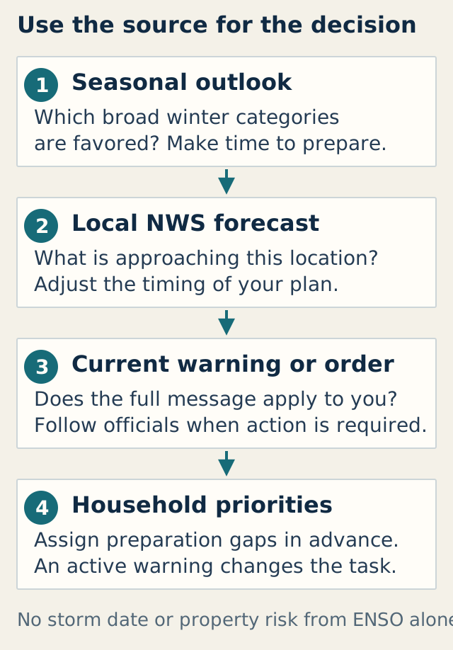
Use each source for its own decision: seasonal context → local forecast → official warning or order → household action. Sources:
CPC outlooks
and
NWS warning definitions
. This sequence is also explained in the paragraphs here.
Read the seasonal product to decide what to prepare before winter. As a storm approaches, use the local forecast to adjust timing. If a warning or order applies, follow the complete official instructions and stop routine property work. An article or planning tool cannot replace that change of task.
Choose three winter priorities
In the next 30 minutes: check the current official sources, locate local alerts, and list the three gaps that most affect your household. This is a suggested planning session, not an agency deadline. Give each gap a person and one next action.
Over a dry weekend: send maintenance requests, test existing lighting and charging arrangements according to their manuals, review the care or relocation plan, and make essential documents accessible. Leave work involving roofs, wiring, plumbing, or unstable slopes to the appropriate qualified person.
When a storm is approaching: review the current local forecast, household contacts, route information, and unfinished items. During a warning, follow officials; an incomplete checklist is not a reason to delay departure or enter a hazardous area.
Household Winter Priority Card
Copy this card into your own notes or print it. Complete three rows with actions you can control or assign. The site collects and saves no information from this card.
| Preparation gap | Next action | Responsible person | Completion timing |
|---|---|---|---|
Planning boundary: Reviewed September 29, 2026 using NOAA CPC, WMO, NWS, and CDC guidance linked in this article. Local warnings and orders take priority. Professional advice is needed for medical, electrical, structural, and drainage decisions. Source page: homeresiliencehub.com/blog/urban-prepping/el-nino-2026-27-home-preparedness/.
Common questions
Is a 75% historic-strength forecast a 75% chance of flooding?
No. NOAA’s September number refers to its October–December RONI event-strength threshold. Flood risk is a separate question requiring local forecasts, exposure information, and current warnings.
Can I rely on the 1997–98 winter as a preview?
Use it as a reason to prepare, not a prediction. The 2015–16 comparison shows why similar broad event strength can produce different regional rainfall. The historical table deliberately uses observations and forecasts in separate rows.
Do I need to buy backup power because of El Niño?
Start with the dependency, existing equipment, safe use constraints, and an alternative location. Some households need a professional continuity plan; others have higher-priority alert or maintenance gaps. The Outage Readiness Planner below organizes those decisions without prescribing equipment or certifying safety.
When will this forecast need checking again?
NOAA’s next scheduled ENSO discussion is October 8, 2026. We plan monthly forecast checks during the active event and an end-of-season review in May 2027. Always consult current local forecasts and alerts before a weather-dependent action.