California El Niño 2026–27: How to Prepare Your Home Before Winter Storms
Check how rain, flooding, coastal exposure, slopes, snow, and outages could affect your California home, then assign visible property concerns to the right contact.

In this guideJump to a section
- California status as of September 2026
- Match your home to an exposure to check
- Walk the rain path from roof to street
- El Niño, atmospheric rivers, and storms are different
- Flooding, sandbags, coast, and hillsides
- Power and communication dependencies
- Evacuation and road decisions
- Insurance and document check
- A short property-preparation ladder
- California Property Check Card
- Common questions
Before the next storm, check the water path around your home and decide who can address anything you find. California spans several kinds of flood, coastal, slope, and snow exposure, so a statewide El Niño outlook is only a reason to plan ahead; it cannot tell you whether your block will flood.
For the forecast, historical comparisons, and household-wide priorities, see the national El Niño preparedness guide.
An active warning changes the task
If a current warning or evacuation order applies to you, stop this advance-planning check. Read the complete local NWS message and follow instructions from emergency officials. A flood or flash-flood warning calls for action; follow NWS flood safety guidance and never walk, swim, or drive through floodwater.
The rainy-home hero is an AI-generated illustration, not a photograph of a documented California storm.
California status as of September 2026
The NOAA Climate Prediction Center’s September 10 diagnostic discussion placed the event under an El Niño Advisory and forecast continued strengthening into winter. Its September 17 seasonal outlook favored above-normal October–December precipitation across the southern half of California and areas farther east. A seasonal outlook describes the odds of a broad seasonal category; it does not identify which storm will arrive, when it will arrive, or what rainfall one property will receive.
On September 21, California’s Governor proclaimed a statewide emergency to help mobilize preparedness resources ahead of potential winter storms. That action is not an address-level forecast. Check your city or county alerts, the local National Weather Service forecast office, and the current state guidance again as the season approaches.
Match your home to an exposure to check
Begin with an address-level planning check through Cal OES MyHazards, then compare it with local flood-control, fire, coastal, and emergency-management information. A map helps frame questions; it cannot certify a property as safe.
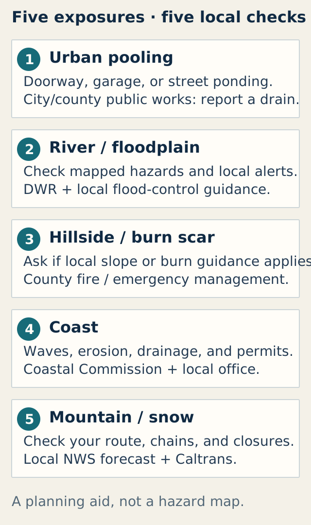
Exposure types call for different local checks. The diagram is a planning aid, not a hazard map. Sources:
California Department of Water Resources
and
California Coastal Commission
.
Five exposure checks
| Exposure | What to check and official resource | Next household action |
|---|---|---|
| Urban pooling | Past ponding near an entrance, garage, or low street point; city or county public-works drainage information | Note the location and report a blocked public drain to the responsible agency. Do not enter traffic or lift a grate. |
| River or floodplain | Address on DWR flood information, MyHazards, and local flood-control guidance | Enroll in local alerts and identify the evacuation route or destination officials specify. |
| Hillside or burn scar | County fire or emergency-management guidance on recent burn areas, debris-flow zones, or slopes | Ask whether guidance applies at this location, save the alert channel, and avoid slopes or drainage channels during rain. |
| Coast | Coastal Commission guidance and local wave, erosion, flood, and permit information | Ask the relevant office before work affecting a bluff, shoreline, or coastal resource. |
| Mountain or snow | Local NWS forecast and Caltrans QuickMap snow, chain controls, closures, and incidents | Check the specific route and save an alternate plan. A seasonal outlook or map does not guarantee an open road. |
Two hypothetical planning examples
A ground-floor renter sees water collect near the entrance. From a dry, safe place, the renter notes where the water appears, when it happens, and whether it is near a public drain or building feature. They send that observation to the property manager and, if a public drain seems obstructed, report it to public works. They do not clear a street drain or wait to act if an official alert directs evacuation.
A household is unsure whether a burn area or slope affects its location. It checks MyHazards, then contacts county emergency management or the agency responsible for that burn area to ask which alerts and local instructions apply. A map marker or its absence does not replace that local answer or a qualified slope assessment.
Walk the rain path from roof to street
Choose a dry day. From the ground, look at gutters and downspouts, visible discharge points, low spots near doors, and the route rain takes toward the street or yard. Photograph concerns only from a safe location. Do not climb a wet roof or ladder, enter standing water, dig near foundations, move heavy covers, or attempt repairs involving electrical, structural, plumbing, or slope conditions.
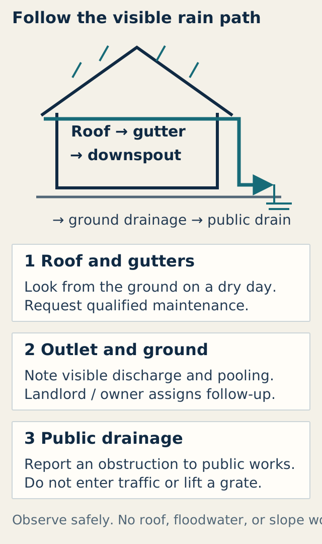
Observe the visible path and assign repairs to the right person. The Coastal Commission’s linked
property checklist is a 2015 edition
; its suggestions are not current permit instructions. Review the Commission’s
September 2026 page
and local requirements before work.
For a home you own, ask a qualified roofer, drainage contractor, or geotechnical professional about damage, persistent ponding, retaining walls, cracks, or slope movement. A renter can document the visible issue and contact the landlord or property manager. A utility handles its equipment; public works handles public drainage. Keep public and private responsibilities separate.
The 2015 Coastal Commission checklist suggests checking gutters, drains, roofs, retaining-wall drainage, and slopes. Its age matters: use it as a prompt for questions, not current construction or permit approval. The Commission’s updated 2026–27 materials advise inspection and routine maintenance, and say some coastal work may require permits. Ask local staff before shoreline, bluff, or other regulated work.
El Niño, atmospheric rivers, and storms are different
El Niño is a broad Pacific climate pattern that can shift seasonal odds. An atmospheric river is a moving band of concentrated water vapor; it can bring rain or snow, and its local effect depends on the weather system and terrain. A storm is a specific weather event with its own forecast, timing, and warnings. The pattern can inform seasonal planning, but only current forecasts and local alerts guide near-term decisions.
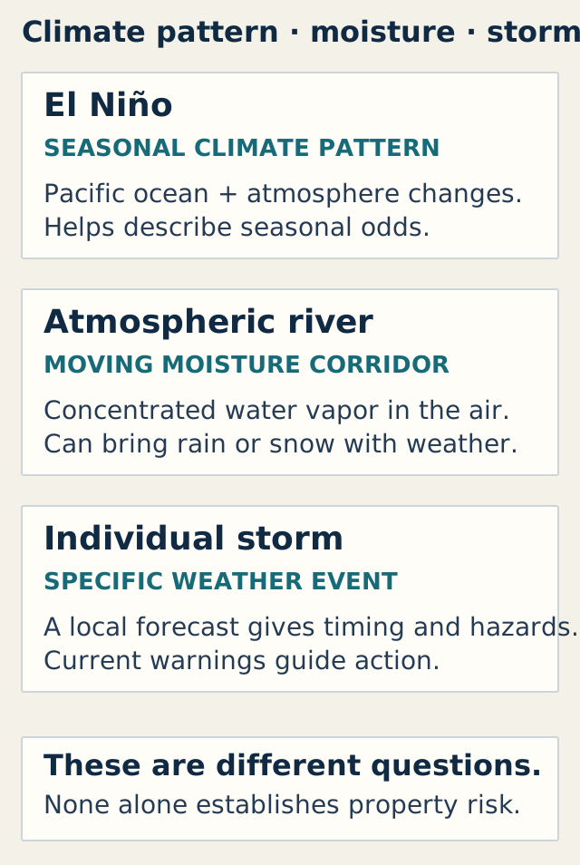
Seasonal context, a weather system, and a specific storm answer different questions. Sources:
NOAA on El Niño
,
NOAA on atmospheric rivers
, and
National Weather Service alert definitions
.
Flooding, sandbags, coast, and hillsides
Flooding can come from rivers, coastal water, intense local rain, fast runoff, or debris flows. DWR lists several flood types in California and directs residents to check local risk and prepare to evacuate. A flood map or seasonal outlook cannot show the depth, speed, or path of water during a particular storm.
Sandbags are not a general fix for a property. DWR suggests having materials ready where flooding is a known concern, while the Coastal Commission cautions that coastal protective work may need a permit. Ask local emergency management or flood-control staff about what is appropriate at your address and where materials are available. Do not place barriers in a public path, block drainage, or attempt shoreline or slope work without the required direction and approvals.
For hillsides and areas below recent burns, use local fire and emergency-management alerts to learn whether post-fire runoff or debris-flow instructions apply. For coastal homes, check local tide, wave, erosion, and flood information; current King Tides information is maintained by the Coastal Commission. In mountain areas, rain can become snow or affect travel conditions; follow current NWS and Caltrans directions for the specific route.
Power and communication dependencies
Rain and wind can interrupt power or communications. List what must keep working—such as a medical device, refrigerator, phone, or lift—and ask the clinician, device supplier, or utility about a household-specific continuity plan, using FDA medical-device guidance and the exact device manual. The Outage Readiness Planner can help organize a household-selected planning duration, essential systems, and backup gaps. It does not forecast how long an outage will last, decide medical suitability, or approve electrical equipment.
Never operate a generator or gasoline-powered engine in a home, basement, or garage. CDC’s January 2026 guidance says to operate a generator outdoors more than 20 feet from doors, windows, and vents, with working battery or battery-backup carbon-monoxide alarms. Distance alone does not approve a site; account for exhaust, weather, neighboring openings, and code. Follow the exact equipment manual and qualified electrical guidance for installation and connection.
Evacuation and road decisions
Choose an evacuation destination and more than one route before a warning. Check current local alerts, then use Caltrans QuickMap for highway conditions and closures. Conditions can change after a map is updated. Never drive through floodwater, around barricades, or onto a road that officials have closed; follow the current warning and responder instructions.
Insurance and document check
Keep copies of key household and property records where you can reach them if you must leave, and note the insurer and policy contact. DWR notes that most homeowners policies do not cover flood damage. FEMA flood-insurance guidance can frame questions; review what your policy covers and ask your insurer about terms, exclusions, documentation, and timing. Coverage and claim requirements vary; this guide cannot interpret a policy or promise a claim outcome.
A short property-preparation ladder
Today: Save county and city alert links, check the address on MyHazards, and find the public-works contact for your street.
Over a dry weekend: Walk the visible rain path from the ground. Note ponding, loose outdoor items, visible gutter problems, or damage that needs a landlord or professional.
Before a storm approaches: Send written maintenance requests, schedule qualified work, review evacuation routes and road information, and check power-dependent needs with the appropriate clinician, equipment supplier, or utility.
During a watch: Read the current message and prepare as directed; avoid outdoor work as conditions deteriorate. During a warning or order: Stop inspection and follow the official action or evacuation instruction.
California Property Check Card
Use this card on paper or in your own notes. Record only what you can safely observe; do not treat it as a structural, drainage, electrical, or slope inspection. The site collects and saves no information from this card.
| Inspection item | Observed issue | Responsible contact | Follow-up action | Completion |
|---|---|---|---|---|
| Roof and visible gutters, from the ground | ||||
| Downspout outlet and visible water path | ||||
| Pooling near entrance, yard, or garage | ||||
| Nearby public drain or street drainage | ||||
| Visible slope, retaining wall, coast, or snow concern |
Boundary: Observe from a safe place. Give maintenance to the landlord or property manager, public drainage to the responsible agency, utility equipment to the utility, and structural, slope, electrical, or plumbing questions to an appropriately qualified professional. During an active warning, follow the official instruction instead of continuing this card.
Reviewed September 29, 2026 using DWR, Cal OES, NWS, and Coastal Commission guidance linked here; the linked property checklist is a 2015 edition. Source page: homeresiliencehub.com/blog/urban-prepping/california-el-nino-2026-27-preparedness/.
Common questions
Does a strong El Niño mean my California home will flood?
No. It can shift seasonal odds, but it cannot identify which block or parcel will flood. Use address-level hazard resources for planning and local forecasts and alerts for current conditions.
Should I install sandbags before winter?
Ask your local emergency-management or flood-control agency whether sandbags are appropriate for your location and where to obtain them. Placement can obstruct drainage, and some coastal protection work requires permits.
Should I clear a storm drain I see blocked?
Do not enter traffic, standing water, or a drain structure. If it appears to be public infrastructure, report its location to the local public-works or drainage agency. For a private drain, contact the property manager or a qualified service provider.
Which route should I take if a storm warning is active?
Follow the complete current alert, evacuation order, road closure, and responder direction. Check official road information when time allows, and never enter floodwater or drive around a closure.